all 37 comments

sorted by: hot top controversial new old
[โ€“] 427 points 1 year ago (4 children)

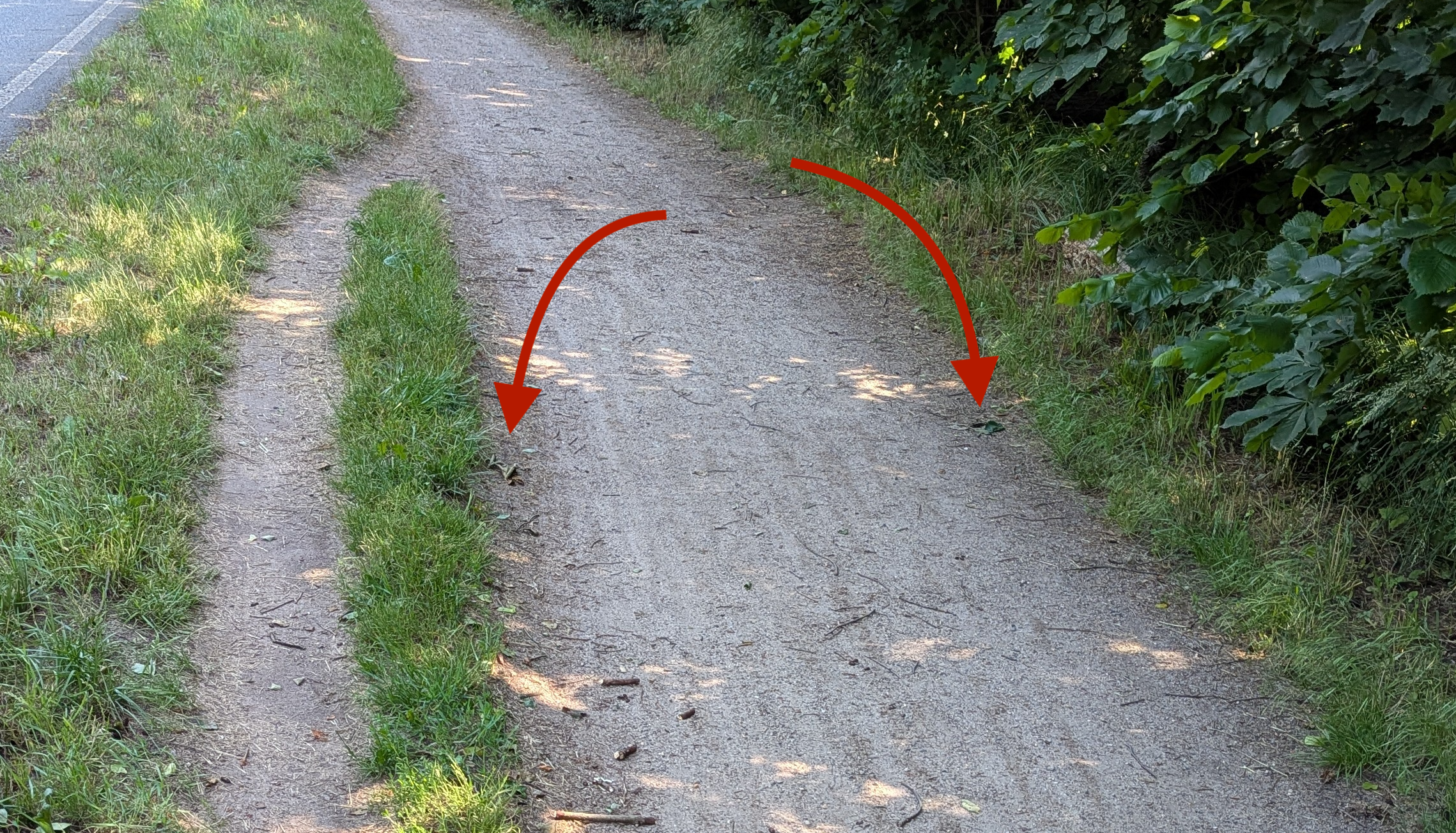
Low spot on the trail. When it rains, mud pit.

  • source
  • hideshow 8 child comments
  • [โ€“] 3 points 1 year ago (2 children)

    Hmmm maybe, but the left is on a slope. The real path is lower, why wouldn't the rain pool there?

    Here's a baseless guess: someone dumped something big on the trail there for awhile and a path formed from the detour and never went away

  • source
  • parent
  • hideshow 4 child comments
  • [โ€“] 3 points 1 year ago (2 children)

    It's hard to tell from a picture, but to me, the road looks higher and everything slopes down to the right.

  • source
  • parent
  • hideshow 4 child comments
  • [โ€“] 109 points 1 year ago* (3 children)

    The main path has a puddle there after rain. Source: British.

  • source
  • hideshow 6 child comments
  • [โ€“] 63 points 1 year ago* (2 children)

    it looks like there could have been metal posts at these spots, maybe a fence to only let pedestrians through, and cyclists started going around
  • source
  • hideshow 4 child comments
  • [โ€“] [S] 29 points 1 year ago (1 child)

    This was my hypothesis as well, but I didn't detect any position where a gate might have been. I'm quite sure the two spots you indicated are leaves.

  • source
  • parent
  • hideshow 2 child comments
  • [โ€“] 11 points 1 year ago (2 children)

    if you know the original location, maybe check on street-view / satellite views. Google Earth also has the option to check older footage

  • source
  • parent
  • hideshow 4 child comments
  • [โ€“] [S] 8 points 1 year ago (1 child)

    I found the exact location for anyone interested: https://maps.app.goo.gl/RtuV3jA3MskYCgvE9

    The desire path can be seen on streetview.

  • source
  • parent
  • hideshow 2 child comments
  • [โ€“] 7 points 1 year ago* (1 child)

    very cool! I looked in the city archives, there were building projects in 2011 and 2019 in that area, but there was no documentation about this particular spot, only that the way was too narrow and the surface material not adequate.

    https://www.stadt-strausberg.de/wp-content/uploads/2018/01/NSZ-2011-09-Amtsblatt.pdf

    https://www.stadt-strausberg.de/wp-content/uploads/2021/06/2021-05-06_Radnutzungskonzept_2021-03-25_A-RN026-BerichtMaerz2021inklMassnah.pdf

  • source
  • parent
  • hideshow 2 child comments
  • [โ€“] 23 points 1 year ago (1 child)

    Could have been tree overgrowth that has since been pruned.

  • source
  • hideshow 2 child comments
  • [โ€“] 22 points 1 year ago*

    I do not think in the mud puddle theory. There is a moat right to the right where rain would drain. There is also no depression for holding any puddle.

    I think there is a depression in the treeline and grass and also slightly on the road. I would say that there has been a broken/bend tree/bush laying in the way for over a year and was recently removed. There is no debre left, as the grass was also cut recently by a machine that also could have picked up any leaves.

  • source
  • [โ€“] 15 points 1 year ago

    The desire to overtake

  • source
  • [โ€“] 15 points 1 year ago* (1 child)

    ...wait this isn't secretly a minelaying tips community is it?

  • source
  • hideshow 2 child comments
  • [โ€“] 9 points 1 year ago

    Maybe shared pedestrian & bike trail? Bikes going around people

  • source
  • [+] 8 points 1 year ago* (last edited 10 months ago) (1 child)
  • If this is in the US I would guess the city put a giant flashing "Share the Road" sign there for a while and everybody had to go around.

  • source
  • [โ€“] 4 points 1 year ago

    Looks like a bike track. Maybe that spot tends to be very muddy after rain, and therefore bikers drive around it?

  • source
  • [โ€“] 3 points 1 year ago

    It looks narrow down further so this would be a natural passing spot

  • source