▲ 430 ▼ Global population density (www.visualcapitalist.com) submitted 2 years ago* by Blaze@sopuli.xyz to c/map_enthusiasts@sopuli.xyz 46 comments fedilink hide all child comments Another website: http://www.luminocity3d.org/WorldPopDen/#6/37.545/16.556 Source: https://ourworldindata.org/grapher/population-density
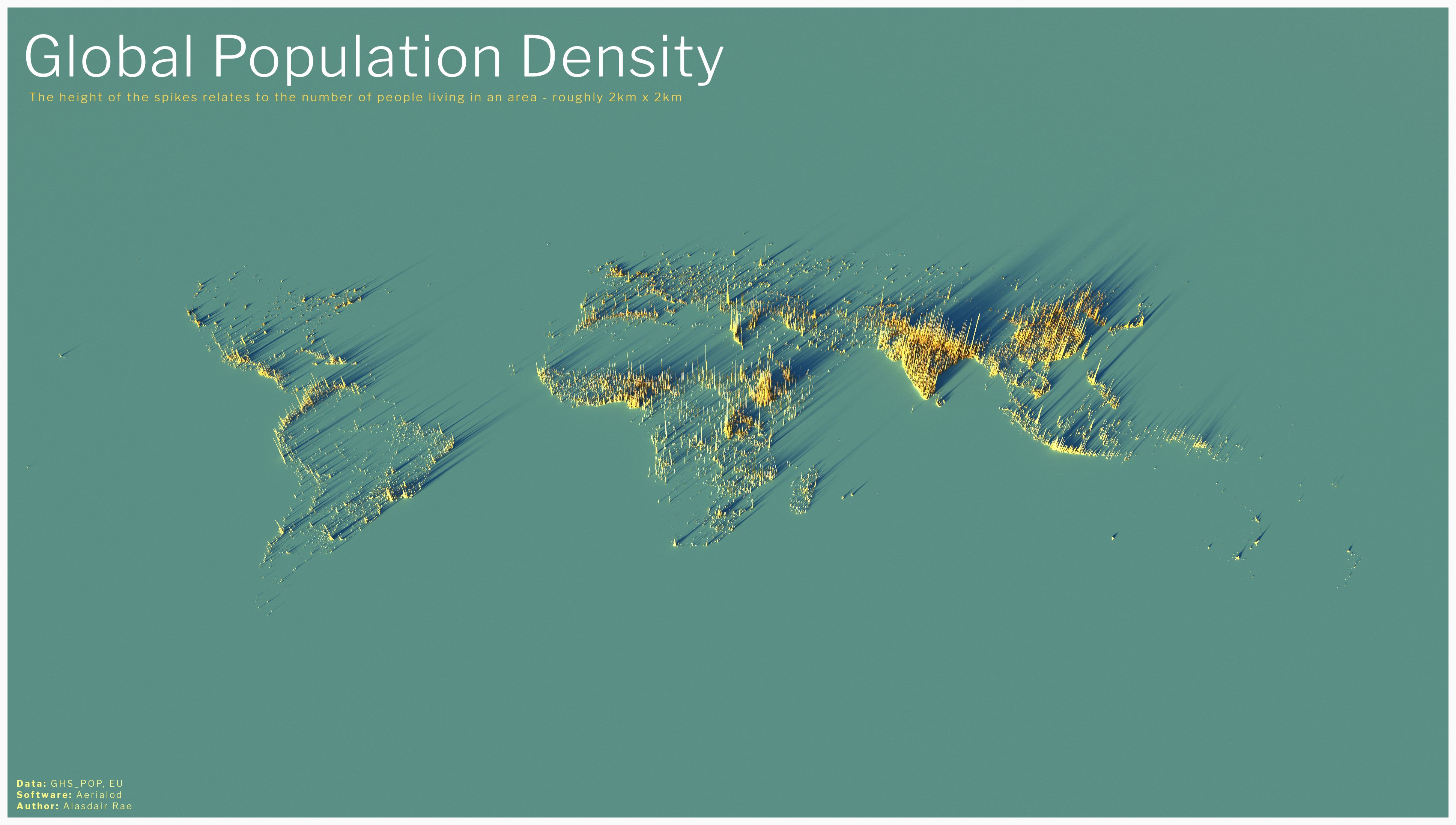
[–] eighty@lemmy.world 64 points 2 years ago (1 child) Great visual on how sparsely populated Australia is. permalink fedilink source hideshow 2 child comments replies: [–] Zagorath@aussie.zone 27 points 2 years ago (2 children) I like how you can just about make out the shape of Australia's east and south coastlines. permalink fedilink source parent hideshow 4 child comments replies: [–] idiomaddict@lemmy.world 9 points 2 years ago (1 child) I’m not good at geography, but I’m going to pretend that that’s New Zealand and this is revenge for all the times NZ was left off the map. permalink fedilink source parent hideshow 2 child comments replies: [–] Zagorath@aussie.zone 6 points 2 years ago (1 child) But you actually can make out New Zealand!('s North Island.) Auckland is easy to see, and I can just make out Wellington from the preview version. When I look at the full-resolution there are enough dots scattered around to make out the full North Island, plus a couple of the bigger towns on the South Island. permalink fedilink source parent hideshow 2 child comments replies: [–] idiomaddict@lemmy.world 3 points 2 years ago Double New Zealand permalink fedilink source parent [–] atocci@lemmy.world 5 points 2 years ago (1 child) But not Canada at all. I figured it would be Australia that would be completely invisible, but nope, Canada. permalink fedilink source parent hideshow 2 child comments replies: [–] Zagorath@aussie.zone 12 points 2 years ago Not being an island, and having about 90% of the population within 100 km of the US border, really doesn't do Canada any favours in this illustration. permalink fedilink source parent
[–] Zagorath@aussie.zone 27 points 2 years ago (2 children) I like how you can just about make out the shape of Australia's east and south coastlines. permalink fedilink source parent hideshow 4 child comments replies: [–] idiomaddict@lemmy.world 9 points 2 years ago (1 child) I’m not good at geography, but I’m going to pretend that that’s New Zealand and this is revenge for all the times NZ was left off the map. permalink fedilink source parent hideshow 2 child comments replies: [–] Zagorath@aussie.zone 6 points 2 years ago (1 child) But you actually can make out New Zealand!('s North Island.) Auckland is easy to see, and I can just make out Wellington from the preview version. When I look at the full-resolution there are enough dots scattered around to make out the full North Island, plus a couple of the bigger towns on the South Island. permalink fedilink source parent hideshow 2 child comments replies: [–] idiomaddict@lemmy.world 3 points 2 years ago Double New Zealand permalink fedilink source parent [–] atocci@lemmy.world 5 points 2 years ago (1 child) But not Canada at all. I figured it would be Australia that would be completely invisible, but nope, Canada. permalink fedilink source parent hideshow 2 child comments replies: [–] Zagorath@aussie.zone 12 points 2 years ago Not being an island, and having about 90% of the population within 100 km of the US border, really doesn't do Canada any favours in this illustration. permalink fedilink source parent
[–] idiomaddict@lemmy.world 9 points 2 years ago (1 child) I’m not good at geography, but I’m going to pretend that that’s New Zealand and this is revenge for all the times NZ was left off the map. permalink fedilink source parent hideshow 2 child comments replies: [–] Zagorath@aussie.zone 6 points 2 years ago (1 child) But you actually can make out New Zealand!('s North Island.) Auckland is easy to see, and I can just make out Wellington from the preview version. When I look at the full-resolution there are enough dots scattered around to make out the full North Island, plus a couple of the bigger towns on the South Island. permalink fedilink source parent hideshow 2 child comments replies: [–] idiomaddict@lemmy.world 3 points 2 years ago Double New Zealand permalink fedilink source parent
[–] Zagorath@aussie.zone 6 points 2 years ago (1 child) But you actually can make out New Zealand!('s North Island.) Auckland is easy to see, and I can just make out Wellington from the preview version. When I look at the full-resolution there are enough dots scattered around to make out the full North Island, plus a couple of the bigger towns on the South Island. permalink fedilink source parent hideshow 2 child comments replies: [–] idiomaddict@lemmy.world 3 points 2 years ago Double New Zealand permalink fedilink source parent
[–] atocci@lemmy.world 5 points 2 years ago (1 child) But not Canada at all. I figured it would be Australia that would be completely invisible, but nope, Canada. permalink fedilink source parent hideshow 2 child comments replies: [–] Zagorath@aussie.zone 12 points 2 years ago Not being an island, and having about 90% of the population within 100 km of the US border, really doesn't do Canada any favours in this illustration. permalink fedilink source parent
[–] Zagorath@aussie.zone 12 points 2 years ago Not being an island, and having about 90% of the population within 100 km of the US border, really doesn't do Canada any favours in this illustration. permalink fedilink source parent