▲ 526 ▼ And then just going about your day (media.piefed.world) submitted 5 months ago by The_Picard_Maneuver@piefed.world to c/justpost@lemmy.world 124 comments fedilink hide all child comments
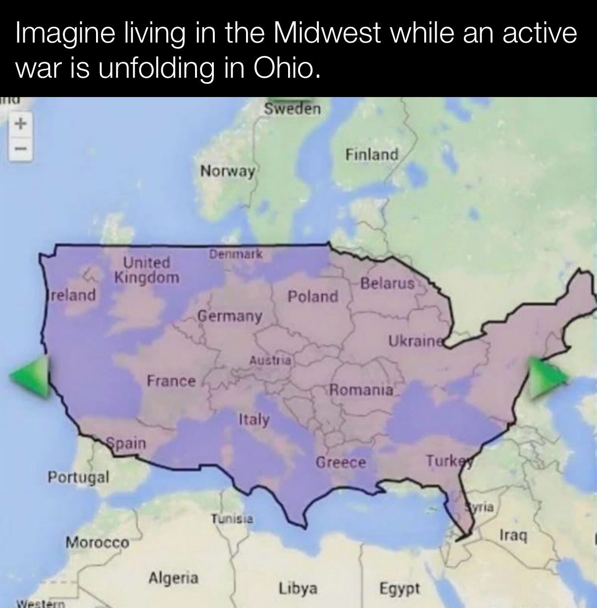
[–] Atomic@sh.itjust.works -1 points 5 months ago (2 children) The two "maps" are wildly out of proportions anyway. Looks like Sweden is the size of the entire US West Coast. When in reality it's about the size of California permalink fedilink source parent hideshow 4 child comments replies: [–] mrmule@sh.itjust.works 2 points 5 months ago* (1 child) One of the most common criticisms of the Mercator map is that it exaggerates the size of countries nearer the poles, while downplaying the size of those near the equator For example, let's move Russia towards the equator permalink fedilink source parent hideshow 2 child comments replies: [–] Atomic@sh.itjust.works 1 point 5 months ago Mercator does compensate for that by introducing reference rectangles. But of course, that doesn't help when people making posts using those maps, are unaware of how to read them. And also just remove said reference rectangles permalink fedilink source parent [–] captain_aggravated@sh.itjust.works 2 points 5 months ago (1 child) Given how the US border is distorted (Maine is north of the 49th parallel) I'm guessing this is one of those maps that distorts things as you move them around to keep the area constant. Like look how big Greenland looks up in the corner. permalink fedilink source parent hideshow 2 child comments replies: [–] Atomic@sh.itjust.works 1 point 5 months ago (1 child) Greenland is not in the image permalink fedilink source parent hideshow 2 child comments replies: [–] captain_aggravated@sh.itjust.works 2 points 5 months ago (1 child) Then what is the unlabeled landmass at the very top left, northeast of Iceland? permalink fedilink source parent hideshow 2 child comments replies: [–] Atomic@sh.itjust.works 2 points 5 months ago* (1 child) The landmass in the very top left on the image in this post. Is Iceland. Greenland is not northeast of Iceland either. It's northwest. permalink fedilink source parent hideshow 2 child comments replies: [–] captain_aggravated@sh.itjust.works 1 point 5 months ago (1 child) I meant this one, from earlier in this thread. permalink fedilink source parent hideshow 2 child comments replies: [–] Atomic@sh.itjust.works 1 point 5 months ago Right. Sorry, my bad. permalink fedilink source parent
[–] mrmule@sh.itjust.works 2 points 5 months ago* (1 child) One of the most common criticisms of the Mercator map is that it exaggerates the size of countries nearer the poles, while downplaying the size of those near the equator For example, let's move Russia towards the equator permalink fedilink source parent hideshow 2 child comments replies: [–] Atomic@sh.itjust.works 1 point 5 months ago Mercator does compensate for that by introducing reference rectangles. But of course, that doesn't help when people making posts using those maps, are unaware of how to read them. And also just remove said reference rectangles permalink fedilink source parent
[–] Atomic@sh.itjust.works 1 point 5 months ago Mercator does compensate for that by introducing reference rectangles. But of course, that doesn't help when people making posts using those maps, are unaware of how to read them. And also just remove said reference rectangles permalink fedilink source parent
[–] captain_aggravated@sh.itjust.works 2 points 5 months ago (1 child) Given how the US border is distorted (Maine is north of the 49th parallel) I'm guessing this is one of those maps that distorts things as you move them around to keep the area constant. Like look how big Greenland looks up in the corner. permalink fedilink source parent hideshow 2 child comments replies: [–] Atomic@sh.itjust.works 1 point 5 months ago (1 child) Greenland is not in the image permalink fedilink source parent hideshow 2 child comments replies: [–] captain_aggravated@sh.itjust.works 2 points 5 months ago (1 child) Then what is the unlabeled landmass at the very top left, northeast of Iceland? permalink fedilink source parent hideshow 2 child comments replies: [–] Atomic@sh.itjust.works 2 points 5 months ago* (1 child) The landmass in the very top left on the image in this post. Is Iceland. Greenland is not northeast of Iceland either. It's northwest. permalink fedilink source parent hideshow 2 child comments replies: [–] captain_aggravated@sh.itjust.works 1 point 5 months ago (1 child) I meant this one, from earlier in this thread. permalink fedilink source parent hideshow 2 child comments replies: [–] Atomic@sh.itjust.works 1 point 5 months ago Right. Sorry, my bad. permalink fedilink source parent
[–] Atomic@sh.itjust.works 1 point 5 months ago (1 child) Greenland is not in the image permalink fedilink source parent hideshow 2 child comments replies: [–] captain_aggravated@sh.itjust.works 2 points 5 months ago (1 child) Then what is the unlabeled landmass at the very top left, northeast of Iceland? permalink fedilink source parent hideshow 2 child comments replies: [–] Atomic@sh.itjust.works 2 points 5 months ago* (1 child) The landmass in the very top left on the image in this post. Is Iceland. Greenland is not northeast of Iceland either. It's northwest. permalink fedilink source parent hideshow 2 child comments replies: [–] captain_aggravated@sh.itjust.works 1 point 5 months ago (1 child) I meant this one, from earlier in this thread. permalink fedilink source parent hideshow 2 child comments replies: [–] Atomic@sh.itjust.works 1 point 5 months ago Right. Sorry, my bad. permalink fedilink source parent
[–] captain_aggravated@sh.itjust.works 2 points 5 months ago (1 child) Then what is the unlabeled landmass at the very top left, northeast of Iceland? permalink fedilink source parent hideshow 2 child comments replies: [–] Atomic@sh.itjust.works 2 points 5 months ago* (1 child) The landmass in the very top left on the image in this post. Is Iceland. Greenland is not northeast of Iceland either. It's northwest. permalink fedilink source parent hideshow 2 child comments replies: [–] captain_aggravated@sh.itjust.works 1 point 5 months ago (1 child) I meant this one, from earlier in this thread. permalink fedilink source parent hideshow 2 child comments replies: [–] Atomic@sh.itjust.works 1 point 5 months ago Right. Sorry, my bad. permalink fedilink source parent
[–] Atomic@sh.itjust.works 2 points 5 months ago* (1 child) The landmass in the very top left on the image in this post. Is Iceland. Greenland is not northeast of Iceland either. It's northwest. permalink fedilink source parent hideshow 2 child comments replies: [–] captain_aggravated@sh.itjust.works 1 point 5 months ago (1 child) I meant this one, from earlier in this thread. permalink fedilink source parent hideshow 2 child comments replies: [–] Atomic@sh.itjust.works 1 point 5 months ago Right. Sorry, my bad. permalink fedilink source parent
[–] captain_aggravated@sh.itjust.works 1 point 5 months ago (1 child) I meant this one, from earlier in this thread. permalink fedilink source parent hideshow 2 child comments replies: [–] Atomic@sh.itjust.works 1 point 5 months ago Right. Sorry, my bad. permalink fedilink source parent
[–] Atomic@sh.itjust.works 1 point 5 months ago Right. Sorry, my bad. permalink fedilink source parent